Where are you going? Select ContinentAfricaAsiaAustralia OceaniaEuropeMiddle EastNorth AmericaSouth AmericaAllWhat type of maps do you need? Select ActivityOn the RoadOn the WaterOn the TrailOn the GreenAll
Need a map update?
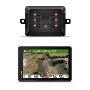
Update the maps that came with your device for the best navigation experience.
Check for Updates
General
Dimension
9.65″ W x 6.06″ H x 0.83″ D (24.5 x 15.4 x 2.1 cm)
Weight
Total: 28.5 oz (806 g)
Head Unit: 19.5 oz (554 g)
Display Type
10.1″ wide view IPS, color TFT, with on-lens capacitive touch panel
Display Size
8.5″ W x 5.3″ H (21.6 x 13.5 cm); 10.1″ (25.7 cm) diagonal
Display resolution
1280 x 800 pixels
Dual-orientation display
Magnetic Mount
1″ ball adapter with AMPS plate
Battery Type
rechargeable lithium-ion
Battery life
up to 2 hours
Maps & Memory
Data cards
microSD™ card (not included)
Preloaded street maps
High Definition 3D terrain
yes (Outdoor Maps+ Subscription)
3D Terrain
yes (Outdoor Maps+ Subscription)
Internal storage
64 GB
Ability to add maps
yes (Outdoor Maps+ Subscription)
External memory storage
microSD™ card (not included)
Includes map updates
yes (Outdoor Maps+ Subscription)
Downloadable Satellite Imagery
yes (Outdoor Maps+ Subscription)
TOPO map support
yes (Outdoor Maps+ Subscription)
Downloadable USGS Quad Sheets
yes (Outdoor Maps+ Subscription)
Sensors
GPS
Galileo
Barometric altimeter
Compass
yes (when out of mount)
10 Hz multi-GNSS positioning
Outdoor Recreation
Point-to-point navigation
Preloaded topographical maps
Preloaded US public land boundaries
Preloaded private land parcel maps
yes (parcels greater than 4 acres)
Preloaded USFS Roads and Trails, including motor-vehicle-use-maps for motorcycle, ATV, SXS and full-size 4×4
Navigate-a-track navigation
Turn-by-turn trail navigation
Compatible with Outdoor Maps+ Subscription
Camera Features
Backup camera compatible
yes (BC 50)
Navigation Features
Garmin Real Directions™ landmark guidance
TripAdvisor® Traveler Ratings
Route shaping through preferred cities/streets
Includes traffic
yes (with Alpha Mobile app)
Lane assist with junction view (displays junction signs)
yes (with Alpha Mobile app)
Bluetooth® pairing
Speed limit indicator (displays speed limit for most major roads in the U.S. and Europe)
Driver alerts for sharp curves, school zones, red light and speed camera warnings and more
Advanced Features
Smart notifications via app
Wi-Fi® map and software updates
Access to live services via app (traffic, weather, etc.)
Connectivity
Smartphone platform compatibility
iPhone® , Android™
Works with Garmin app on a compatible smartphone
yes (with Alpha Mobile app)
Range (via smartphone or other Bluetooth® source)
30 ft (10 m)
Motorcycle Features
Garmin Adventurous Routing™
Track support
Custom map support
Wireless ANT+® technology
Adventure Features
Pair with compatible inReach® devices
Track recorder (breadcrumbs)
iOverlander™ points of interest
Ultimate Public Campgrounds
Pitch and Roll gauges
Birdseye Satellite Imagery (download via Wi-Fi)
Dog Tracking Features
Radio Frequency Band
MURS (151-154 MHz)
Tracking/training range
up to 9 miles
Tracks
up to 20 assets (any combination of compatible dog devices and handhelds)
Update rate
up to 2.5 sec
Dynamic update
Track log
20,000 points
Stored contacts
250 dogs
Group management
PRO view compass
Channel view
Training features
yes (stim, tone and vibration via touchscreen)
Hunt metrics
Electrical Features
Power Source
12V in-vehicle socket
Outdoor Applications
Dog tracking